CV
Glenn Vancauwenberghe
Summary
Independent researcher and consultant in the domains of geospatial data, data infrastructures and digital transformation
Education
- Ph.D in Social Sciences2013KU Leuven (Belgium)
- MSc. in Management of Public Administration2007Ghent University (Belgium)
- MSc. in Social Sciences2006KU Leuven (Belgium)
Work Experience
- Owner and Senior Expert2025 - ...GEONOTGEO, Belgium
- Research Manager2018 - 2024Spatial Applications Division Leuven (SADL), Katholieke Universiteit Leuven, Belgium
- Post-doctoral Researcher2016 - 2018Knowledge Centre Open Data, TU Delft, the Netherlands
- Senior Researcher2012 - 2016Spatial Applications Division Leuven (SADL), Katholieke Universiteit Leuven, Belgium
- Junior Researcher2007 - 2011Public Governance Institute (PGI), Katholieke Universiteit Leuven, Belgium
Publications
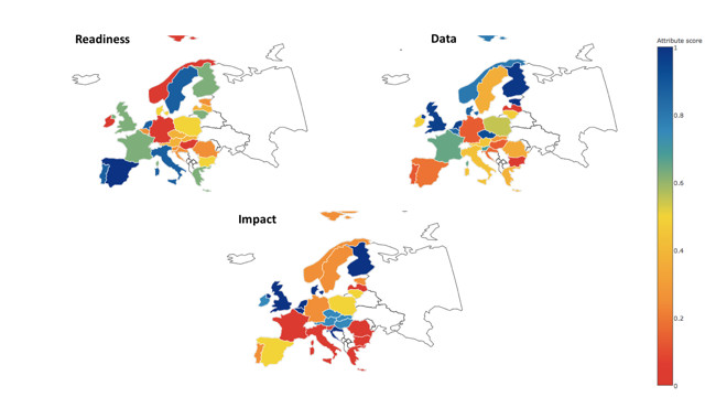
- Evolution of the access to spatial data for environmental purposes2022JRC Technical ReportThis study investigates how different user communities in Europe are accessing and using spatial data, the problems they are facing and how they see the impact of various policy initiatives on improving the accessibility and usability of data.
- Geospatial Information Infrastructures2020Manual of Digital EarthGeospatial information infrastructures (GIIs) provide the technological, semantic, organizational and legal structure that allow for the discovery, sharing, and use of geospatial information (GI). In this chapter, we introduce the overall concept and surrounding notions such as geographic information systems (GIS) and spatial data infrastructures (SDI).
- Assessing the Openness of Spatial Data Infrastructures (SDI): Towards a Map of Open SDI2018International Journal of Spatial Data Infrastructures ResearchThis paper introduces the Open Spatial Data Infrastructure (SDI) Assessment Framework as a new approach for assessing the openness of SDIs.
- Open Data Exposed2018SpringerThe main objectives of this book are to expose key aspects that have a relevance when dealing with open data viewed from different perspectives and to provide appealing examples of how open data is implemented worldwide.
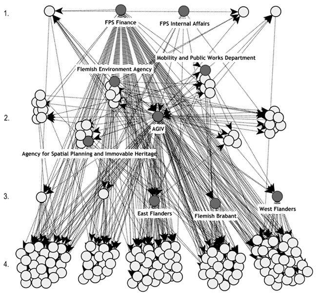
- Coordination in the context of Spatial Data Infrastructures2013PhD ThesisIn my PhD research I explored how different coordination instruments and mechanisms are used to coordinate the exchange of, the access to and to use of spatial data.
Teaching
- Organisational components of Spatial Data Infrastructures2024KU Leuven, Geospatial Information TechnologiesRole: Guest lecture
- Increasing impact through effective communication, dissemination and exploitation2024ODECO Training Week 4 'Towards an inclusive open data ecosystemRole: Training
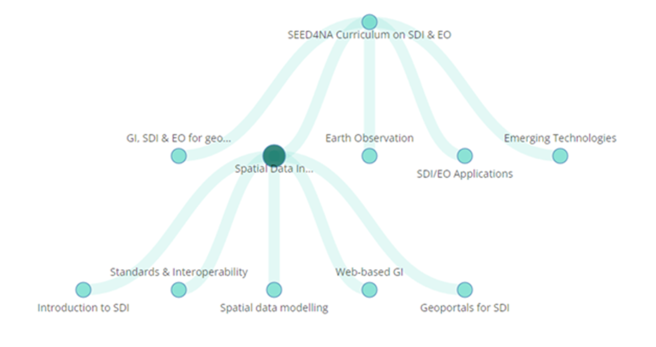
- Business and funding models2022SEED4NA Training on Basics of SDIRole: Online training
- Location Intelligence for Cities and Regions2019ELISE Knowledge TransferRole: Webinar
- Assessment of Spatial Data Infrastructures2018Delft University of Technology, Geo-information Organisation and LegislationRole: Lecture
Portfolio
- SPATIALIST - SDI for Public Sector Innovation (2007-2011)2011
- Effective Governance of Open Spatial Data (2016-2018)2018
- SEED4NA - Spatial Data Infrastructures and Earth Observation Education and Training for North-Africa (2020-2024)2024