
European Union Location Framework (2013-2016)
This is a summary of the report ‘European Commission: Joint Research Centre, Vandenbroucke, D., Vancauwenberghe, G., Crompvoets, J., Pignatelli, F., Smits, P., Boguslawski, R., Vowles, G., Borzacchiello, M.T. (2014). Assessment of the Conditions for a European Union Location Framework. Luxembourg: Publications Office of the European Union’. The full report can be found here).
The European Union Location Framework (EULF) aimed to maximise the benefit from the vast amount of money spent on location-related information and services by governments across Europe by promoting a best practice approach for cross-sector and cross-border sharing and use of this information. The EULF was developed under the ISA programme which supported interoperability solutions, sharing and reuse among European Public Administrations through the creation of frameworks, architectures and re-usable components to enable more cost effective e-Government services and support cross-border applications.
The report ‘Assessment of the Conditions for a EULF’ provided an assessment of the state of play in the different focus areas of the EULF and the need for EULF action in these areas. In the report the use and integration of location information was assessed at different levels. The report explored the relevance and importance of location information in different policy areas, policy themes and different types of policy actions, but also looked at the processes through which the implementation of policies takes place, and how these processes make use of location information. For collecting the information used in this assessment, different methods were applied in order to capture and analyse a maximum of information and to maximise interaction with stakeholders.
An important stage of the assessment was the design and implementation of the ‘EULF Survey on use and integration of location information within e-Government’. The main objective of this survey was to collect information on the current integration and use of location data in e-Government in EU Member States. The survey also aimed to get insight in the initiatives and actions taken at Member Assessment of the Conditions for a European Union Location Framework State level to support and facilitate the integration of location data in eGovernment. 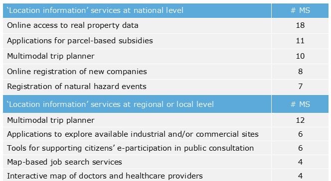
The EULF survey collected information on the use of location information in the delivery of services to citizens and businesses. Based on a list of 10 services, all making use of location information (5 services to citizens, 5 to businesses), Member States were asked to indicate which of these services were available in their country and at which level these services are provided (national, regional, local or as single best practice). Typical examples of services that already exist at national level are online access to real property information, multimodal trip planners, applications for parcel-based subsidies and registration of recent natural hazard events. Services that are mainly provided at the local level are tools for supporting citizens’ e-participation in public consultation, applications to find and explore available industrial and/or commercial sites and also multimodal trip planners.
In addition, Member States also had the opportunity to add other services provided to citizens or businesses. Interesting examples are: reporting ecological problems, online access to cadastral information, citizens’ events maps, and portals for water management facilities. Also several examples of cross-border services were provided by the Member States, such as applications for the management and protection of international rivers, and applications to manage the deployment of emergency services.
A selection of public sector processes were analysed to provide additional insight on how location information was integrated in different process steps and in the interactions between governments, citizens and businesses. The integration of location information and services with other types of information and services seems to be a necessary condition for realising the full potential of location information in public sector processes and creating benefits for public authorities, citizens and businesses.