
Evolution of the access to spatial data for environmental purposes (2022)
This is a summary of the report ‘European Commission: Joint Research Centre, Vancauwenberghe, G. and Hernández Quirós, L. (2022). Evolution of the access to spatial data for environmental purposes – A study on the past, present and future of spatial data infrastructures in Europe. Luxembourg: Publications Office of the European Union, 2022’. The full report can be found here.
Solving all the problems related to the access and use of spatial data could result in savings of around € 150 million. That was one of the main conclusions of the 2009 study on the “Use of spatial data for the preparation of environmental reports in Europe”, one of the first in-depth studies on the benefits and impact of spatial data and spatial data infrastructures (SDI).
By repeating the 2009 study, the study on “Evolution of the access to spatial data for environmental purposes” aimed to collect and provide evidence on how the access and use of spatial data for environmental purposes have evolved over the last decade. In that decade, the Infrastructure for Spatial Information in the European Community (INSPIRE) was established, and various other policy initiatives were taken to improve the availability, accessibility and interoperability of public sector data, and spatial data in particular. In 2020, the European Commission launched its European Data Strategy to make the European Union a leader in a data-driven society.
The 2022 study investigated the impact of different policy initiatives on improving access and use of spatial data, including the expected impact of the European Data Strategy and the key components and priorities in implementing this strategy. In this way, the study looked at the past, present and future of accessing and using spatial data in Europe from a user-centric perspective, investigating how users were accessing and using spatial data, the problems they were facing and how they saw the impact of various policy initiatives on improving the accessibility and usability of data. This investigation enhanced understanding of how SDIs and INSPIRE, in particular, should evolve towards data ecosystems and contribute to establishing the European Green Deal Data Space.
The study was based on a survey of spatial data users and practitioners in the spatial data community in Europe. The survey was primarily targeted at persons and organisations using spatial data for environmental purposes and particularly at practitioners involved in preparing Environmental Impact Assessment (EIA) and Strategic Environmental Assessment (SEA) reports. However, other stakeholders in the geospatial domain were invited to participate in the survey and provide insight into how they are accessing and using spatial data to support their work. 129 respondents from 22 different European countries completed the survey. Approximately 60% of the respondents were working in the environmental field, and half of them were involved in preparing environmental assessments. Respondents included experts and practitioners working in the public sector, private sector and other sectors, such as researchers or individual citizens.
The study showed that in the preparation of environmental assessments, spatial data are mainly used to support the identification of impacts, the visualisation and presentation of impacts and simple analyses and processing to forecast impacts. That was already the case in 2009, which seemed to indicate that the way of using spatial data for environmental assessment did not significantly change in the past ten years. The only exception to this was using spatial data for more advanced analysis and processing, which was done more frequently. Looking at the overall use of spatial data, for environmental assessments and other purposes, the study identified a set of spatial data themes relevant for most users, with local and regional authorities, environmental agencies, and mapping cadastral agencies as the major data provides. Among the key data themes were land cover, land use, protected sites, administrative units, hydrography, transport networks, cadastral parcels and various other themes. Interesting trends observed were the increased use of self-generated data, citizen-generated data and private data. Another interesting observation was that only a small part of the respondents use spatial data in transboundary and/or multi-country activities.
 ”
”
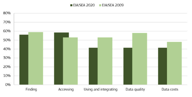
The main finding concerning challenges in discovering, accessing and using spatial data was that practitioners in the geospatial domain were encountering the same problems as in the past, although to a slightly lesser degree. While problems related to the quality of data and the use and integration of data seemed to be less common, EIA and SEA practitioners seemed to experience more problems with accessing the data they needed. Another important finding was that the impacts of these different problems on the EIA/SEA process seemed to be stronger, indicating the costs of non-interoperability in the geospatial domain. When comparing the EIA/SEA practitioners with other users and user communities, it seemed that problems with accessing spatial data and with the costs of spatial data were more common among the EIA/SEA practitioners, while practitioners outside the environmental domain especially seemed to face problems with the quality of data.
The study investigated the awareness among the respondents on both the INSPIRE Directive and the more recent European Data Strategy. The majority of the respondents were familiar with INSPIRE, but the respondents were much less aware of the European Data Strategy and its plan to establish a single market for data. Concerning the actual impact of various policy initiatives, the respondents confirmed that initiatives such as the INSPIRE Directive, the Copernicus Programme, and the Open Data Directive significantly influenced spatial data availability. The main impact of INSPIRE especially was improving the discoverability, availability and accessibility of data. Concerning the observed impact of these different initiatives, there seemed to be interesting similarities and important differences between the different types of practitioners and organisations involved in the survey, which should be further investigated and considered to further implement existing and future initiatives. Looking, for instance, at the impact of the INSPIRE Directive, it seemed that government organisations especially saw an impact on improving the discoverability and availability of data, while businesses and other organisations evaluated this impact differently. Also, between EIA/SEA practitioners, environmental practitioners and practitioners outside the field of environment, the impact of INSPIRE was evaluated differently.