
SEED4NA - Spatial Data Infrastructures and Earth Observation Education and Training for North-Africa (2020-2024)
Initiatives to promote and coordinate the sharing of spatial data are emerging in the region of Northern Africa, at the local, national and regional level. Despite the growing availability of data, there are several barriers and challenges hindering the uptake and use of these data. Among these barriers and challenges is a lack of skills and knowledge on Spatial Data Infrastructures (SDI) and Earth Observation (EO) among key stakeholders, and the aim of SEED4NA was to address these skills needs.
The main objective of SEED4NA was to improve the quality of higher education in North Africa in the fields of Spatial Data Infrastructures (SDI) and Earth Observation (EO), and enhance its relevance for the job market and society through the development and offering of new and innovative SDI/EO courses. Among the specific objectives were to develop the required knowledge, skills and competencies on SDI & EO and to support the introduction of SDI and EO courses in at the partner universities.
Key activities implemented within the project include a comprehensive skills needs assessment, a multi-stage training program covering different aspects of SDI/EO and how to teach about them, the development of teaching practices and materials on relevant topics, and the preparation and implementation of revised and new courses dealing with SDI, EO and related topics. In additional, several activities also directly targeted professionals and other stakeholders in the geospatial domain.
The SEED4NA project brought important improvements in the relevance, quality and impact of higher education on SDI, EO and related topics at the eight partner universities in North Africa. Fundamentals of SDI/EO and more advanced topics were introduced in more than 25 different courses, resulting into a new generation of students mastering the key aspects of SDI and EO and able to contribute to future SDI/EO developments in the region of North Africa.
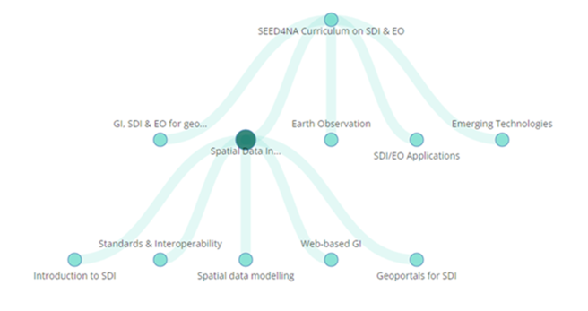
A key task within the project dealt with the specification and adaptation of the project curriculum in SDI and EO. This was done based on the results of analyses of existing SDI/EO education in Europe and in North Africa, and an in-depth assessment of the skills requirements of SDI/EO stakeholders and practitioners in North Africa. The five building blocks of the SEED4NA Curriculum on SDI/EO are shown in the figure above: GI, SDI and EO for geospatial solutions, Spatial Data Infrastructures, Earth Observation, Applications of SDI and EO, and Emerging technologies. For each of these building blocks we also identified several key components. The figure shows the key components of the building block ‘Spatial Data Infrastructures’. For the design and visualisation of the curriculum we made use of the EO4GEO Curriculum Design Tool (CDT), which allows users to create, edit and find educational offers in the field of Earth Observation and Geographic Information