
Sitemap
A list of all the posts and pages found on the site. For you robots out there, there is an XML version available for digesting as well.
Pages
Posts
Future Blog Post
Published:
This post will show up by default. To disable scheduling of future posts, edit config.yml and set future: false.
Blog Post number 4
Published:
This is a sample blog post. Lorem ipsum I can’t remember the rest of lorem ipsum and don’t have an internet connection right now. Testing testing testing this blog post. Blog posts are cool.
Blog Post number 3
Published:
This is a sample blog post. Lorem ipsum I can’t remember the rest of lorem ipsum and don’t have an internet connection right now. Testing testing testing this blog post. Blog posts are cool.
Blog Post number 2
Published:
This is a sample blog post. Lorem ipsum I can’t remember the rest of lorem ipsum and don’t have an internet connection right now. Testing testing testing this blog post. Blog posts are cool.
Blog Post number 1
Published:
This is a sample blog post. Lorem ipsum I can’t remember the rest of lorem ipsum and don’t have an internet connection right now. Testing testing testing this blog post. Blog posts are cool.
portfolio
SPATIALIST - SDI for Public Sector Innovation (2007-2011)
Network analysis of the SDI of Flanders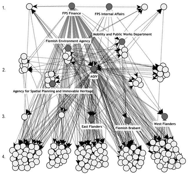
SmeSpire - A European Community of SMEs built on Environmental Digital Content and Languages (2012-2014)
Impact of INSPIRE among small and medium-sized enterprises in Europe
European Union Location Framework (2013-2016)
Location information services in EU Member States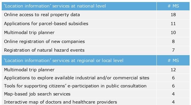
Effective Governance of Open Spatial Data (2016-2018)
Assessing the Openness of Spatial Data Infrastructures (SDI)
The role of the Spatial Data Infrastructure in the Digital Transformation of Public Administration (2018-2019)
Insights on the role of SDI in Digital Transformation in Spain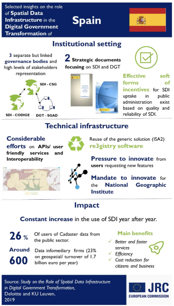
EO4GEO - Towards an innovative strategy for skills development and capacity building in the space and geo-information sector to support Copernicus user uptake (2018-2022)
GI/EO job advertisements analysis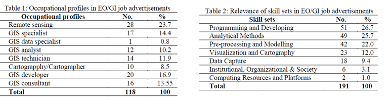
Evolution of the access to spatial data for environmental purposes (2022)
Problems with spatial data experienced by practioners, differences between 2009 & 2020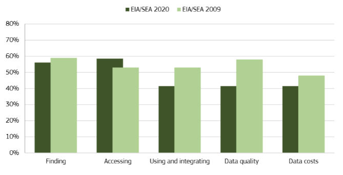
SPIDER - Open Spatial Data Infrastructure Education Network (2020-2022)
Mapping of SDI Education in Europe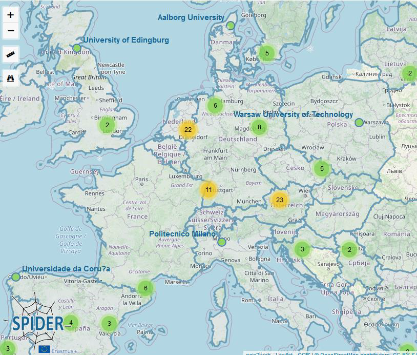
SEED4NA - Spatial Data Infrastructures and Earth Observation Education and Training for North-Africa (2020-2024)
SEED4NA Curriculum on SDI/EO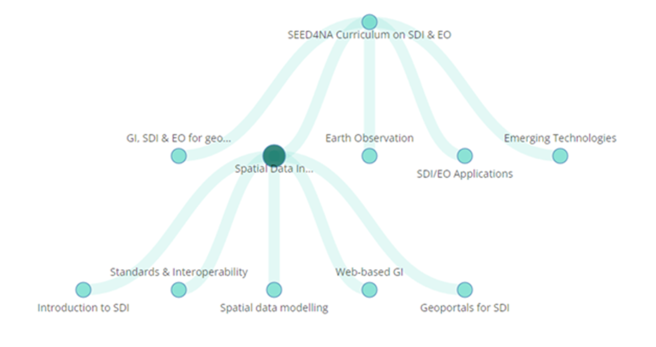
DIS4SME - Data Interoperability Skills for SMEs (2023-2025)
Analysis of training resources on location data interoperability 
publications
Paper Title Number 1
Published in Journal 1, 2009
This paper is about the number 1. The number 2 is left for future work.
Recommended citation: Your Name, You. (2009). "Paper Title Number 1." Journal 1. 1(1).
Download Paper | Download Slides
Paper Title Number 1
Published in Journal 1, 2009
This paper is about the number 1. The number 2 is left for future work.
Recommended citation: Your Name, You. (2009). "Paper Title Number 1." Journal 1. 1(1).
Download Paper | Download Slides
Paper Title Number 2
Published in Journal 1, 2010
This paper is about the number 2. The number 3 is left for future work.
Recommended citation: Your Name, You. (2010). "Paper Title Number 2." Journal 1. 1(2).
Download Paper | Download Slides
Paper Title Number 3
Published in Journal 1, 2015
This paper is about the number 3. The number 4 is left for future work.
Recommended citation: Your Name, You. (2015). "Paper Title Number 3." Journal 1. 1(3).
Download Paper | Download Slides
Paper Title Number 4
Published in GitHub Journal of Bugs, 2024
This paper is about fixing template issue #693.
Recommended citation: Your Name, You. (2024). "Paper Title Number 3." GitHub Journal of Bugs. 1(3).
Download Paper
talks
Talk on Gigalite
Published:
This is a description of your talk, which is a markdown file that can be all markdown-ified like any other post. Yay markdown!
Tutorial on Lou
Published:
Conference Dax
Published:
This is a description of your conference proceedings talk, note the different field in type. You can put anything in this field.
Talk 2 on Open Data
Published:
teaching
SDI and coordination
Lecture, SPATIALIST Seminar 'Spatial Data Infrastructures (SDI): latest trends and research’, 2011
During the SPATIALIST Scientific Seminar on ‘Spatial Data Infrastructures (SDI): latest trends and research’, a lecture was provided on coordination in the context of Spatial Data Infrastructures. In this lecture, research results from the SPATIALIST project were provided to demonstrate how different coordination mechanisms can be used for dealing with various coordination challenges in developing and implementing SDIs.
INSPIRE advanced
Training, SmeSpire Vocational training programme, 2014
This training module dealt with how INSPIRE could become a key enabler in e‐Government business processes. It placed the INSPIRE Directive in the context of other policy initiatives and broader technological developments and explained the future developments of INSPIRE and its maintance programme. and broader technological developments.
How free are free data and tools?
Training, VLIRUOS-funded Short Training Initiative, 2014
As part of the 2014 Short Training Initiative ‘Discovery, exploration and exploitation of free data and tools for supporting the adaptation of agriculture and forestry to climate change’, a training was provided on the topic of free data and tools.
Basics of INSPIRE Data and service sharing
Training, LINKVIT Vocational Training programme, 2015
This training module aimed at providing professionals with a better understanding of the European legislation on data access, re-use and sharing, with a key focus on the requirements of the INSPIRE Directive regarding the sharing of data and services.
Geo-information Organisation and Legislation
Course, TU Delft, MSc Geomatics, 2017
As part of the MSc course ‘Geo-information Organisation and Legislation’ (TU Delft, MSc Geomatics), lectures were provided on the governance and assessment of Spatial Data Infrastructures, and students were trained in the development and application of an assessment framework for evaluating the openess of an SDI.
The role of geospatial in the digital government transformation
Webinar, ELISE Knowledge Transfer, 2019
The aim of this webinar was to set the scene and explore the broad role of geospatial data and SDIs as important enablers and building blocks of digital government transformation. The webinar placed past and ongoing developments in the use and sharing of geospatial data in the wider context of digital transformation.
Spatial Data Infrastructures & Digital Government Transformation
Lecture, Pontificia Universidad Católica del Perú (PUCP), 2019
A guest lecture was provided to students from the Pontificia Universidad Católica del Perú (PUCP) on Spatial Data Infrastructures in the context of Digital Government Transformation.
The role of Spatial Data Infrastructures for Digital Government Transformation
Webinar, ELISE Knowledge Transfer, 2019
The aim of this webinar was to review the role of Spatial Data Infrastructures (SDIs) in the Digital Transformation of Government and explore how SDIs should further evolve to increase its contribution to this transformation. The webinar built on a study commissioned by the EC Joint Research Centre in which a methodology was developed for better understanding the role of SDIs in the Digital Transformation of the public sector and applied to investigate the role between SDIs and Digital Transformation in different European countries
SDI & (Open) Data Policies
Training, NSDI Mozambique - SDI for Managers Training , 2019
Training was provided to representatives from various public organisations in Mozambiqua on (open) data policies in the context of Spatial Data Infrastructures. The training module looked at SDI and its relations with other data policies, and open data policies in particular. The module also discussed the applicability of open data licences in the context of SDIs.
SDI in support of work processes
Training, NSDI Mozambique - SDI for Managers Training , 2019
In this training session, several representatives from government organisations in Mozambique learned about how SDI data and components can be used to support the work processes of government – and other – organizations. The module explained what work processes are and how processes and their main components coulld be identified. The module also looked at the mapping and modelling of processes through business process modelling tools and languages.
Distribution of tasks in the context of SDI
Training, NSDI Mozambique - SDI for Managers Training , 2019
The aim of this training session was to explain the importance of task allocation in the context of Spatial Data Infrastructures, and present different models for allocating tasks in the development and implementation of SDIs. In this module, the allocation of tasks and responsibilities is introduced as an instrument for the governance of SDIs.
Digital Twins - Are they ready to embrace the benefits of location information?
Webinar, ELISE Knowledge Transfer, 2020
The aim of this webinar was to explore the importance of “geospatial” and “interoperability” in the creation and management of digital twins. In this webinar, the current state of play on the development and deployment of digital twins in Europe and how they rely on geospatial data, data infrastructures and technologies were presented.
Location Intelligence for cities and regions: preparing the ground for smart places of the future
Webinar, ELISE Knowledge Transfer, 2020
The webinar on Location Intelligence for Cities and Regions presented state of the art and future perspectives on the use of location data and technologies by local and regional governments. The webinar aimed to demonstrate how location intelligence is vital for turning subnational governments into smart places.
Curriculum implementation - From descriptions to courses
Online training, SEED4NA Virtual Summer School , 2021
During the SEED4NA Virtual Summer School, teachers and researchers from different North African universities learned about constructive alignment & blended course design for active teaching about Spatial Data Infrastructures.
Business and funding models
Online training, SEED4NA Training on Basics of SDI, 2022
As part of the SEED4NA Training on the Basics of SDI, an online training session was organised on the topic of ‘Business and funding models’. In this session, teachers and researchers from different North African universities learned about the notion of business models and how to apply it to SDIs, as well as about the costs of establishing SDIs and how to cover them.
Network perspective on SDI
Online training, SEED4NA Training on Basics of SDI, 2022
A training session on SDIs from a network perspective was organised to explain why SDIs are important and how they can be successful in addressing different challenges in the access to and sharing of geospatial data.
SDI Establishment
Training, SEED4NA Summer School, 2022
During the 2022 SEED4NA Summer School, which took place in Dubvronik (Croatia), teachers from the SEED4NA partner universities were training in how to design and offer education about the establishment of Spatial Data Infrastructures.
User needs through co-creation
Lecture & Serious game, SPIDER Summer School on Open SDI, 2022
As part of the SPIDER Summer School on Open SDI, which took place in August 2022, students in the domains of open data & geomatics participated in a serious game to learn more about implementing Open SDIs throuh co-creation.
Increasing impact through effective communication, dissemination and exploitation
Training, ODECO Training Week 4 'Towards an inclusive open data ecosystem', 2024
During the 4th training week of the ODECO project, which focused on the topic of inclusive data ecosystems, PhD students from different disciplines were introduced into the basics of communication, dissemination and exploitation, for increasing the impact of their work.
SDI policies and non-technological components
Keynote presentation, NSDI Georgia, Stakeholder meeting, 2024
In this keynote presentation an introduction was provided to the non-technological components of Spatial Data Infrastructures, with a particular emphasis on relevant policies.
The organisational components of Spatial Data Infrastructures
Lecture, KU Leuven, Geospatial Information Technologies, 2024
As part of the MSc course ‘Geospatial Information Techonologies’ a lecture was provided on the organisational components of Spatial Data Infrastructures. In this lecture, students were introduced into the topics of SDI assessment, licensing, governance models, business models and SDI funding.